Updated December 5, 2022
When you are on an adventure in the wilderness, a GPS is an essential tool to plan your movements, keep track of your location, and maintain personal safety.
Today’s handheld GPS devices pack a lot of sophistication and capabilities into a small, convenient casing. They are easy to use and can literally be lifesaving.
Choosing the best handheld GPS in 2021 means you need to wrap your head around the complexities of the technology and a batch of specifications. To help in this research some of the best in the range have been selected as an introduction to the possibilities. There’s a comparison table to start, followed by specs, features, pros & cons, photos, some excellent brief video presentations, and a buying guide. I strongly recommend checking out the videos to consolidate and clarify the information.
Please use the comments section at the bottom if you have any questions or concerns. I’d love to know your thoughts.
For more information on hiking and camping gear, please check out these reviews:
Hiking Binoculars Hiking Watches Mess Kits Hiking Shoes Hiking Boots Portable Showers for Camping Backpacking Water Filters Headlamps Night Vision Binoculars Marine Binoculars Backpacking Stoves Backpacking Tarp Shelters Camping Knives Backpacking Tents Backpacking Backpacks Backpacking Sleeping Pads Camping Beds Portable Toilets Bivy Sacks Camping Hammocks Backpacking Sleeping Bags Ultralight Tents SUV Tents 4 Season Tents Truck Tents 4 Person Tents Beach Tents
Best Handheld GPS Review
- Garmin inReach Mini
- Garmin inReach Explorer+
- Garmin GPSMAP 66sr
- Garmin Foretrex 601
- Magellan eXplorist 310
- Garmin eTrex 10
- Garmin eTrex 35t
- Garmin Montana 700
Best Handheld GPS Comparison Table
| Picture | Handheld GPS | Weight Battery Life Screen Size | Price |
|---|---|---|---|
 | Garmin inReach Mini | 3.5 ounces 50 hours 1.27 inches | $$$ |
 | Garmin inReach Explorer+ | 7.5 ounces 100 hours 2.31 inches | $$$$ |
 | Garmin GPSMAP 66sr | 8.2 ounces 36 hours 3 inches | $$$$ |
 | Garmin Foretrex 601 | 3.1 ounces 48 hours 2 inches | $$ |
 | Magellan eXplorist 310 | 5.2 ounces 18 hours 2.2 inches | $$ |
 | Garmin eTrex 10 | 5 ounces 25 hours 2.2 inches | $ |
 | Garmin eTrex 35t | 5.6 ounces 16 hours 2.6 inches | $$$ |
 | Garmin Montana 700 | 14 ounces 18 hours 5 inches | $$$$$ |
| Picture | Handheld GPS | Weight Battery Life Screen Size | Price |
Specifications

- Best For: hiking, emergency preparedness
- Weight: 3.5 ounces
- Display Size: 1.3 inches
- Battery Type: rechargeable lithium-ion
- Battery Life: up to 90 hours (in 10-minute tracking mode)
- Memory: 6.5 MB, can save up to 500 waypoints
- Touchscreen: no
- Wireless Connectivity: Bluetooth, ANT+
- Warranty: 1-year limited
- Price: $$$
Other Features
- IPX7 water-resistance
- 2-way messaging capability
- Interactive SOS trigger and tracking features
Pros: easy-to-read (though small) display, waterproof, lightweight, and compact, a 2-way messaging feature
Cons: limited mapping and navigation capability, requires a paid subscription for messaging features
Specifications

- Best For: hiking, navigation, emergency preparedness
- Weight: 7.5 ounces
- Display Size: 2.31 inches
- Battery Type: rechargeable lithium-ion
- Battery Life: up to 100 hours in 10-minute tracking mode, 30 days in power-saver mode
- Memory: 2 GB, can save up to 500 waypoints
- Touchscreen: no
- Wireless Connectivity: Bluetooth
- Warranty: 1-year limited
- Price: $$$$
Other Features
- IPX7 water-resistance
- 2-way messaging capability
- Interactive SOS trigger and tracking features
- Pre-loaded topographical maps with onscreen GPS routing
- Ability to add maps with a free app paired with compatible mobile devices
- Built-in digital compass, barometric altimeter, and accelerometer
Pros: easy-to-read display, waterproof, 2-way messaging capability, several features including compass, barometric altimeter, and accelerometer not included in the inReach Mini
Cons: a little heavy, limited navigation capability, requires a paid subscription for messaging features, fairly expensive
Specifications

- Best For: hiking, navigation
- Weight: 8.2 ounces
- Display Size: 3 inches
- Battery Type: rechargeable lithium-ion
- Battery Life: up to 36 hours in standard mode, 450 hours in expedition mode
- Memory: 16 GB, expandable, 10,000 waypoints, 250 routes
- Touchscreen: no
- Wireless Connectivity: Bluetooth and ANT+
- Warranty: 1-year limited
- Price: $$$$
Other Features
- IPX7 water-resistance
- GPS, GLONASS, Galileo, QZSS sensors
- Livetrack safety and tracking feature
- Real-time weather when paired with a Smartphone
- Compatible with Garmin Explore website and services
- Pre-loaded detailed topo-active and hydrographic maps with the ability to add maps
- Built-in 3-axis compass, barometric altimeter, and LED flashlight
Pros: bright readable color display, accurate positioning, fast-tracking, subscription-free satellite imagery, large memory
Cons: heavy, battery life is limited, fairly expensive
Specifications

- Best For hiking, back-country skiing, tactical applications (hunting, shooting, military)
- Weight: 3.1 ounces
- Display Size: 2 inches
- Battery Type: 2 AAA alkaline batteries
- Battery Life: up to 48 hours in navigation mode, 1 week in battery saver mode, 1 month in watch mode
- Memory: 500 waypoints, 20 routes
- Touchscreen: no
- Wireless Connectivity: Bluetooth and ANT+
- Warranty: 1-year limited
- Price: $$
Other Features
- IPX7 water-resistance
- GPS, GLONASS, Galileo sensors
- Livetrack feature with Garmin Connect mobile app
- Night goggle compatible
- Compatible with multiple sensors including heart rate strap, speed/cadence sensor, Garmin VIRB action camera, and Garmin temperature sensor (all not included)
- Built-in 3-axis accelerometer, 3-axis compass, GPS compass, and barometric altimeter, water-resistant
Pros: clear display, good battery life with easily replaceable AAA batteries, accurate positioning, hands-free navigation, water-resistant, durably constructed to military standards, reasonable price
Cons: can’t download maps
Specifications

- Best For hiking
- Weight: 5.2 ounces
- Display Size: 2.2 inches
- Battery Type: 2 AA alkaline batteries
- Battery Life: up to 18 hours of standard use, has a suspend, power-saving mode
- Memory: 500 MB of user-available memory for topographical maps, geocaches, tracks, and waypoints
- Touchscreen: no
- Wireless Connectivity: Bluetooth and ANT+
- Warranty: 1-year limited
- Price: $$
Other Features
- IPX7 water-resistance
- Preloaded world edition map
- Paperless geocaching
- High-sensitivity SiRFstarIII GPS
- Dashboard shows a mini-compass, customizable data fields, trip odometer, distance to end, latitude, longitude, heading, tracking, and more
Pros: bright, sunset-readable color display, waterproof, easy-to-use interface, reasonable battery life with easily replaceable batteries, low-priced
Cons: can’t download maps, older design and technologies

Specifications
- Best For: hiking, cycling
- Weight: 5 ounces
- Display Size: 2.2 inches
- Battery Type: 2 AA alkaline batteries
- Battery Life: up to 25 hours
- Memory: 6 MB, 1,000 waypoints, 50 routes
- Touchscreen: no
- Wireless Connectivity: Bluetooth and ANT+
- Warranty: 1-year limited
- Price: $
Other Features
- IPX7 water-resistance
- Pre-loaded worldwide base map
- Paperless geocaching
- GPS and GLONASS sensors
- GPS compass (when moving)
- Hunt/fish calendar, sun and moon information
- Compatible with Basecamp software for organizing and viewing maps, waypoints, tracks, and routes
Pros: low-priced, easy-to-use interface, waterproof, bright monochrome display, compact, lightweight
Cons: minimal mapping capability, small storage memory
Specifications

- Best For hiking
- Weight: 5.6 ounces
- Display Size: 2.6 inches
- Battery Type: 2 AA lithium batteries
- Battery Life: up to 16 hours
- Memory: 4 GB internal and expandable, 200 routes, 4,000 waypoints
- Touchscreen: yes
- Wireless Connectivity: Bluetooth and ANT+
- Warranty: 1-year limited
- Price: $$$
Other Features
- IPX7 water-resistance
- Preloaded worldwide base map, 100k topographical maps for the US
- 3-axis digital compass, GPS compass (when moving), barometric altimeter
- 250,000 preloaded geocaches
- GPS and GLONASS sensors
- Smart notifications
Pros: touchscreen color display, easy-to-use interface, waterproof, compact, lightweight
Cons: low battery life
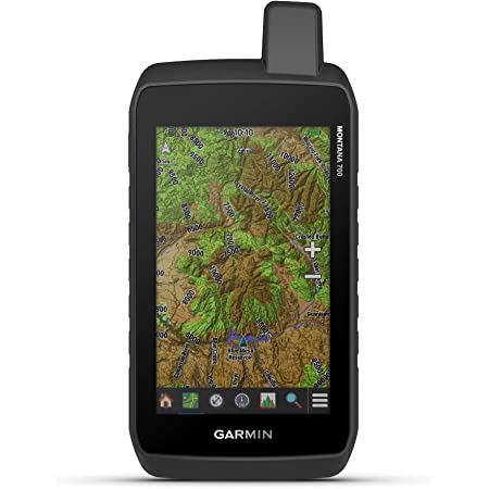
Specifications

- Best For: hiking, backcountry motorized activities, navigating
- Weight: 14 ounces
- Display Size: 5 inches
- Battery Type: 2 AA rechargeable lithium-ion batteries
- Battery Life: up to 18 hours in GPS mode, 330 hours in expedition mode
- Memory: 16 GB internal and expandable, 250 tracks, 10,000 waypoints
- Touchscreen: yes
- Wireless Connectivity: Bluetooth and ANT+
- Warranty: 1-year limited
- Price: $$$$$
Other Features
- IPX7 water-resistance
- Preloaded topoactive and base maps
- 3-axis digital compass, GPS compass (when moving), barometric altimeter
- Geocaching friendly
- GPS, GLONASS, Galileo sensors
- Numerous daily Smart features
- Livetrack feature
Pros: glove-friendly large touchscreen color display, easy-to-use interface, waterproof, powerful navigational capabilities, lots of maps included, large memory, Smart features, tracking
Cons: expensive, heavy
Best Handheld GPS Buying Guide
Global Navigation Satellite Systems (GNSS)
GNSS refers to the whole range of satellite systems that these handheld devices can connect to for positioning support. Historically GPS (US) has been the dominant system. Today there are many others including GLONASS (Russia), QZSS (Japan), Galileo (EU), BeiDou (China), and others. Some of the devices available rely on only GPS but if yours can get support from more than one of these systems, it is more likely that regardless of the terrain you will have a greater ability to connect with the most precise location fix.
Touchscreen Versus Buttons
The touchscreen interface is becoming more and more prevalent in the marketplace. Navigation is intuitive and faster especially when typing is required. In cold weather the use of gloves can be a hindrance, however, some models are compatible with glove use. Buttons can be more durable and some users find pushing buttons to navigate is easier or better suits their style. Of the models reviewed here only the Garmin eTrex 35t and Garmin Montana 700 offer the touchscreen feature.
Display
Large screen size is especially useful for hunting, boating, and motorized activities where more details and information are more easily visible at a glance. For hiking and backpacking where a lightweight and compact size are priorities, smaller displays are the norm. Regardless of the size, you want a clear, bright display. Monochrome screens are still in use and are battery-efficient but often lack clarity. Larger, color displays can be seen more easily and those that perform well in bright sunlight or are backlit for night use are desirable. The downside is that these are more expensive.
Battery Type and Battery Life
For many of the adventures that involve a handheld GPS, there is not a good opportunity to recharge the batteries. Historically AA and AAA batteries were the norms that had the advantage of being easily switched out when the power is drained.
Today there are models that use rechargeable lithium-ion batteries that can be charged at home or on the go. If you have to bring a charger with you it can be a major inconvenience depending on your mission. Solar panels and power banks are an option for some models.
There are devices that can operate on both rechargeable and disposable batteries.
It’s important to know how much battery life you have at your disposal and the differences in usage time in the various modes.
Mapping and Memory
Most handheld GPS devices come with a base map loaded with at least some basic local features like points of interest, elevation, and roads or trails. Many include additional preloaded maps and/or the possibility of uploading more later that can provide more detail and customization.
Much of the data saved in a handheld device is in the form of waypoints, routes, and similar data that requires a certain amount of memory. Additional maps that can be loaded may require more memory than your device has built-in. Most of the best modern devices allow for the use of a MicroSD slot for the necessary expandable memory to add more maps.
Messaging and Emergency Features
A number of GPS handheld devices have the ability to transmit and sometimes receive messages via satellite, which is especially useful when cell phone service is not accessible. The service can also include an SOS trigger for emergencies. Often requiring a paid subscription, it is available on the Garmin inReach Mini and Garmin inReach Explorer+ devices reviewed above.
Altimeter, Barometer, and Compass (ABC)
Many handheld devices above the most basic level have a barometric sensor that measures barometric pressure allowing calculation of altitude. Not absolutely precise for that purpose because pressure changes also come with changes in the weather, but it does provide a fair idea of elevation.
A compass may also be incorporated. This can be in the form of an electronic 3-axis compass which can read direction no matter what position the compass is in. Standard compasses require it to be oriented horizontally. A GPS compass may also be included which can only give a heading when you are in motion (but not when standing still).
Handheld GPS Versus Smartphone GPS Apps
For wilderness activities, adventurers who may be tempted to use the GPS capabilities of their smartphones, handheld GPS devices have several advantages. They are compatible with a wider range of satellite systems as opposed to Smartphones that are limited in access to GPS satellites and cell towers that may not provide coverage to all locations. There are fairly good quality mapping apps available for Smartphones which may require a fee. A major downside is that these can quickly use up battery power. Smartphones are also not as durable, robust, or waterproof enough to stand up to the elements as well as a handheld GPS.
For more information on hiking and camping gear, please check out these reviews:
Hiking Binoculars Hiking Watches Mess Kits Hiking Shoes Hiking Boots Portable Showers for Camping Backpacking Water Filters Headlamps Night Vision Binoculars Marine Binoculars Backpacking Stoves Backpacking Tarp Shelters Camping Knives Backpacking Tents Backpacking Backpacks Backpacking Sleeping Pads Camping Beds Portable Toilets Bivy Sacks Camping Hammocks Backpacking Sleeping Bags Ultralight Tents SUV Tents 4 Season Tents Truck Tents 4 Person Tents Beach Tents
Feedback and Comments
I hope you found this post on the best handheld GPS interesting and useful. If you have any questions or ideas, please feel free to share them in the comments section. If there is no comments section directly below, click here: >>comments<<